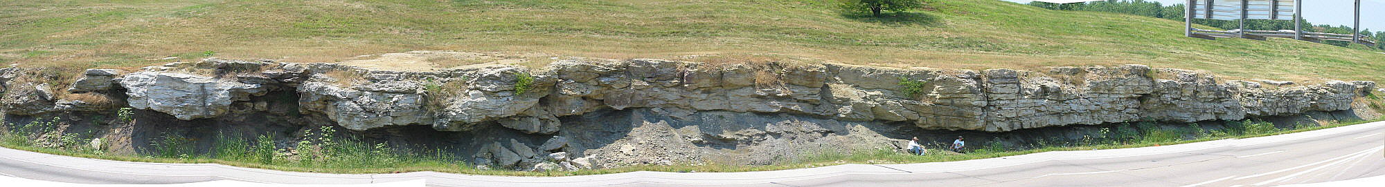
Panorama of the west side of the southbound lanes of I-170. The vertical
highway cut exposes the Worland Limestone Member of the Altamont
Formation, with softer beds of the Lake Neosho Shale Member and the
Bandera Formation exposed beneath. The Worland decreases in thickness
above and to the left of the people sitting in front of the outcrop (Barry Sutton
and Norm King's wife, Dr. Joanne Alexandrovich). Originally the vertical face
of the Worland continued straight across, parallel to the highway. The scallop-
shaped widening in the road cut appeared in an instant, as a mass of
limestone weighing hundreds of tons broke loose and slid onto the interstate,
partially blocking traffic. Shaly beds exposed in the high embankment must
be studied to understand the depositional history of the Bandera and
Altamont Formations in this area, yet those beds have been visible for only
a few years, and only in the slide escarpment. A limestone rockfall in the
drainage ditch at center left testifies to the continuing danger of working
beneath the limestone overhang. Rockfalls of similar scale have occurred
with regularity on both sides of the highway. The outcrop has a ragged edge
farther to the left (south) due to karstic dissolution of the limestone. In that
area, beds beneath the Worland have been intensively weathered by rain
water infiltrating through the solution passageways.