Missouri Department
of Natural Resources
Division of Geology and Land Survey
Missouri Geological Survey Section Form
This is not the original picture, the original
was a
drawing with a circle around the exposure.
Page 1 of 3
County: St.
Louis
Elevation: 570-580
(Est.)
Description: S 1/2 SE Section 9 (projected), T, 46 N., R. 6E.
Quadrangle name: Clayton 7 1/2' Quadrangle
Described by: Wallace
B. Howe (late)
Date: 25 October, 1990 (The work done by
Wallace B. Howe on this
date has been transcribed from his field notes. Unfortunately he passed
away before completing the project. These descriptions are included
here for historical perspective.)
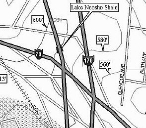
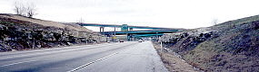
Remarks: Exposures
along I-170 in cuts through a low ESE extension
of SL Airport track; SW of tributary to Maline Creek and across it from
Hanley Rd; cuts about 0.3 to 0.4 mile NNW of I-170 and I-70 intersection
with base Worland at 570-580 feet (Est.), S 1/2 SE Section 9 (projected)
T. 46 N., R. 6E., in City of Berkley, St. Louis Co., Mo., Clayton 7 1/2'
Quadrangle, 1954 (revised 68 and 74)
Description
Note:
a) Apparent thickness as well as presence of upper shale and clay
beds
below the Worland limestone, within the area of cuts, varies
owing
to slumpage and compaction beneath the limestone.
b) Fusulinids occur in abundance in unit 8 , but are not seen
below.
Unit 8 is probably equivalent to limestone identified as
Worland
in most of western and northern Mo.
c) Unit 7 identified as lower Worland; Unit 8 along with
9 and 10
as upper Worland; Unit 6 as upper Lake Neosho; all of the
Altamont Formation.
d) Lower Worland resembles upper 1s. At Page/170 but other
information clearly indicates that they are not the same limestone.
Unit 2 is most probably the bed Knight (1933) identified as the
"R" zone, from which he collected his micro-gastropod faunas.
Page 2 of 3
Section: S 1/2 SE Section 9 (projected), T. 46 N., R. 6 E
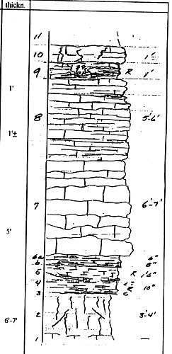
Top
11) Unconsolidated clay and silt, poorly exposed; may include some
post-Worland shale and clay; thickness varies according to modern
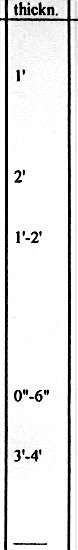
topo, but ranges up to 15 feet or more.
10) Limestone; dolomitic? f-m xln with sandy to silty texture;
bedding indistinct but unit is perforated generally with burrows
and/or plant root molds ( 1/4-1/2 inch +), "bleached" appearance.
9) Limestone; similar to that above; but with thin, irregular bedding;
weathers to consistently stained dull maroon to red; locally replaced
by dull maroon silty claystone; distinct boundary with unit
below.
8) Limestone; clearly distinct from that below; med- to brownish-gray,
weathering brown to tan; mostly medium graifled texture with abundant
fossil material; unit is argillaceous and possibly silty; forms massive
ledge but is characterized by thin to med. Slabby to irregular bedding;
wide variety of marine invertebrate fossils throughout, including
productids, horn corals, crinoidal debris, and fusulinids (F. megista);
thickness ranges from less than 5 to more than 6 feet, averaging
approximately.
7) Limestone; med. Gray, weathering light gray; wavy to irregular
bedding, with some gray, calc. Shale ptgs; abundant fossils in f-m xln
matrix include Phicodothrys crurithyris, crinoidal debris, horn corals;
resembles typical L & M Higginsville, Myrick Station, as well as the
upper limestone at Page/270 and I-up at MO94 (St. Charles) which
(the lower and middle part) is about the same thickness but is
distinctively thinner bedded. Average
6) Shale; deeply weathered along most of exposure, but clearly
includes 3 "- 6' or more of dark sub- fissile shale with subspherical
to
elongate and irregular phosphatic nodules; lower part also deeply
weathered as well as characterized by/with maroon coloration
(locally-derived material?); shaly, as opposed to clay structure
throughout; slumped and variably compressed and squeezed, with
estimated total thickness of about
* Sentence ends here as is. This
is the way it appears on my copy.
Page 3 of 3
Section S 1/2 SE Section 9 (projected). T. 46N., R. 6 E.
Description
5) Clay/claystone; gray, extremely compact/hard; interpreted as
in
stratigraphic position of an underclay; average
4) Clay/claystone; seemingly distinct from that above; strongly
hematitic with maroon and gray variegated color; associated with
underlying shale and irregular basal limestone; average approximately
3) Shale; maroon with deeply oxidized material (see above );
gradational, - and is persistent laterally as compared to irregular
limestone below.
2) Limestone; gray and maroon; extremely argillaceous and massive
to shaly; ferruginous, weathering deep maroon along with shale above;
sparsely fossiliferous to coquinoidal, with brachiopod shells, and other
material reduced to limey powder; seemingly persistent as a variably-
expressed marine horizon, with thickness of less than one inch to as
much as 6 inches (see note).
1) Clay; variegated gray, yellow and maroon; generally compact
and "tough;" interpreted as in stratigraphic position of an underclay;
apparent thickness
0) Ditch-level material apparently in place suggest that a
deeply-weathered massive argillaceous limestone occurs
beneath bed 1.
St.
Louis Pennsylvanian Fossils of the Altamont Formation
Top of
Page